Lines of business


Lines of business

Satellite
Imagery
Imagery
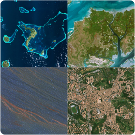
Satellites orbit the Earth at different heights. They are suitable for fire detection, biomass determination, and ozone layer study, to name a few applications.
The satellites that observe the Earth obtain diverse information on natural resources, oceans, urban growth, agriculture, livestock, fishing, forests, natural disasters, and national security, among others.
ImagenGeo is an authorized distributor of the most agile and sophisticated commercial optical and radar imaging satellite constellations that offer very high, high, medium, and low-resolution. Operating daily, they collect billions of km² of images per year.


Geographic
Information
Systems
Information
Systems
Location Intelligence is the art and science of analyzing the connections between geospatial locations (latitude and longitude coordinates) and what exists or happens at these locations (customers, businesses, crime, weather events, traffic, etc.).

Geospatial
Data
Data
ImagenGeo is an official distributor of Precisely’s (formerly Pitney Bowes) Software & Data.

Remote Sensing
We partner with CATALYST (a PCI Geomatics brand) that offers Earth Observation solutions, such as CATALYST Professional, the leading Remote Sensing software, which is simply the best in atmospheric correction, orthorectification, mosaicking, and MDE extraction. Its portfolio allows our clients to make data analysis an easy and profitable practice.

Training
We are the leading private company in Mexico in training in applied technology in earth sciences, aimed at researchers, scientists, advisors, technicians, and any professional who wants to make their work and the resources with which they work more efficient.